MetGIS POINT API
Precise weather information

MetGIS Point API – the reliable and powerful solution for retrieving precise weather data for developers, agencies and decision makers. Through the API, we offer a wide range of weather parameters, including industry-specific parameters, available in a variety of output formats.
Our API allows quick and easy integration of our high-quality data into your software products. Use the MetGIS Point API for your applications and get pinpoint weather forecasts and analyses for any location in the world.
 For websites, apps and business applications
 Ultra-precise weather data with a resolution of up to 30 m
 Available worldwide, even for remote regions
![]() Easy integration & multilingual support
Easy integration & multilingual support
Weather portals and apps | News and tourism websites | Energy: solar, wind, hydro
Big data and machine learning | ad/campaign management | digital services
Agriculture | Transportation and logistics | Severe weather warnings | Events | and much more!
| DATA PACKAGES | STARTER | SMART | PREMIUM | ENTERPRISE |
|---|---|---|---|---|
| Price | From 30,- € / month | From 60,- € / month | From 85,- € / month | Price on request |
| cd4Permitted API Calls | An API call provides weather forecasts for a location, in some cases also current weather, astronomical data and snow cover information. | |||
| per month | up to 100,000 | up to 300,000 | up to 5 million | up to 500 million |
| per second | 10 | 100 | 1.000 | by arrangement |
| Geographic Area | Worldwide | Worldwide | Worldwide | Worldwide |
| Forecast Period | 3 days | 7 days | 10 days | up to 14 days |
| Forecast Update (Data Refresh) | 4 x daily | 4 x daily | 4 x daily | 4 x daily |
| cd4Time Resolution of the Predictions | ||||
| Hourly values | – | – | for 4 days | for 4 days |
| 3-hour values | for 24 hours | for 3 days | for 9.5 days | for 9.5 days |
| 6-hour values | – | – | for 9.5 days | for 9.5 days |
| Daily values | for 3 days | for 7 days | for 10 days | for up to 14 days |
| Data Format | JSON | JSON | JSON | JSON, XML, PDF |
| cd4Weather Forecast | ||||
| Weather code (for icon display), air temperature, wind direction and speed, amount of precipitation | ||||
| Amount of rain, amount of fresh snow, probability of precipitation, probability of thunderstorms, cloud cover | ||||
| Humidity, felt temperature, sunshine duration | ||||
| Fresh snow density, freezing rain, lower and upper cloud limit, zero degree level, snow line, wet bulb temperature | Winter package | |||
| Short-wave radiation (global radiation), long-wave radiation, wind components u and v | Package Solar, Agriculture, … | |||
| Hydrological parameters | Hydrology package | |||
| Forecast short text (approx. 1 – 3 words) | ||||
| Forecast long text (approx. 20 words) | ||||
| cd4Current Weather | ||||
| Weather code (for icon display), air temperature, intensity of rain and snowfall, wind direction and speed | ||||
| Relative humidity | ||||
| Short text current weather (approx. 1 – 3 words) | ||||
| cd4Snow Cover Information | ||||
| Information on the presence of snow cover, including age and sources of information | Snow package | |||
| cd4Astronomy | ||||
| Sun: Rising and setting | ||||
| Moon: rising and setting, moon phase | ||||
| Moon: Illumination | ||||
| cd4Data Retrieval Options | ||||
| Points per query | 1 | 1 | 1 | > 10,000 possible (bulk queries) |
| Route or polygon queries, queries for numerical grids, queries for individual time steps | ||||
| cd4Additional Offer | ||||
| Pro+ GUI (Graphical User Interface) | ||||
| Weather PDF via e-mail (contains forecast texts and graphics) | ||||
| Weather plugins (for WordPress and Joomla) | ||||
| Weather warnings for the whole of Europe | ||||
| Terrain shading API | ||||
| cd4Services | ||||
| Server Up-Time | 99,7 % | 99,8 % | 99,9 % | 99,9 % |
| Support | E-mail support | E-mail support within 24 hours | E-mail/telephone support within a few hours. | Priority Support |
| Payment | annually or monthly | annually or monthly | annually or monthly | annually or monthly |
| Caching of weather data at the customer | no | no | possibly by arrangement | by arrangement |
| Number of API keys | one | one | one | several possible |
| Type of use | No resale | No resale | No resale | by arrangement |
| MetGIS logo: Mandatory display of our logo linked to the MetGIS homepage when publishing weather data | Yes | Yes | by arrangement | by arrangement |
| Ongoing access to query statistics via MetGIS API Monitoring Tool (AMT) | Yes | Yes | Yes | Yes |
| Contractual basis | GTC | GTC | GTC | GTC or individual agreement |

Point APIs provide precise weather data and information for a defined location. They are the foundation for a wide range of applications, including local weather forecasting, climate analysis, agriculture and forestry, energy, tourism, and logistics. Requesting a Point API is very simple. All you need is the latitude and longitude of the desired location. These two numbers define the exact location for which weather parameters will be provided.
Depending on the configuration, this weather information or parameters can be values from the past, present or future (based on forecast calculations). Typical weather parameters are temperature, precipitation, new snow, wind, humidity and global radiation.
Due to the technical structure of a Point API, it is possible to query and calculate a large number of locations. This makes it an ideal solution for applications that require large amounts of weather data.
 Snow
Snow
For ski resorts, avalanche warning services and anyone involved with snow and mountains. The wet bulb temperature is an important parameter for slope management.
 Agricultural sector
For farms and smart farming. Special parameters such as potential evapotranspiration are available.
 Energy
For weather-optimized solutions in the energy sector and associated software and apps. An important parameter available via the Point API is global radiation.
 More
More
For weather apps/portals, retail, web agencies, tourism and many other industries where accurate meteorological forecasts are required.
Please note that a point will only provide the desired weather values for the exact coordinates requested. However, even a small distance can have a significant impact on the weather, especially in mountainous areas. This is where the difference in elevation can lead to the largest deviations.
If you need weather points for mountainous regions, it is better to discuss your planned application with us in advance. This will help you get the most out of our API.

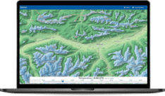
![]() Premium weather data: up to 30 m resolution
Premium weather data: up to 30 m resolution
We are proud to combine innovative weather models with precise terrain data, which is integral to the high quality of our forecasts. This claim is supported by verification studies that have been conducted on several continents since 2007.
 Expert hotline
We don’t hide behind contact forms or chatbots! If you would like to talk to us, simply call us directly. Our meteorologists and IT professionals will be happy to help you on +43 1 890 90 32.
 Test without obligation with Developer Key
See the precision of our weather data for yourself how easy it is to integrate it into your website, app or business application. Follow these steps to test our API for 30 days at no obligation.
Professional API with ultra-precise weather forecasts for the whole world, accurate to 30m.

Weather data from the past with extremely high resolution.
1.
Send https request with coordinates and API key
2.
Immediately receive JSON file with all weather data for the respective coordinate
3.
Extract weather values for the desired period

Get all data for a coordinate in a single API call
No tedious gathering of required data from many different files
All data in local time (instead of UTC!)
No conversion (time zones, winter/summer time) necessary!
All data is based on the local time of the requested coordinates.
Clear structure and descriptive names
Data structured according to time resolution (current weather, 3-hour values, daily values…) with comprehensible designations.
Speak directly to our API developers
If you have any questions or problems, you can contact our developers directly (phone/email/video call). They will always find a solution for you.
Different ways of retrieving weather data
Retrieval by longitude and latitude, zip code, bulk retrievals and much more.
Guarantees the highest level of system availability
Enjoy the reliability of our API, which is available more than 99.85% of the time!
Do you have questions about our services or any other questions, simply fill out the contact form or send us an e-mail.
We also look forward to your call.

Meteorologe, Entwickler des Designs des MetGIS Prognosesystems
Curriculum vitae
This will close in 0 seconds
This will close in 0 seconds